Description
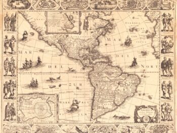
‘Americae sive qvartae orbis partis nova et exactissima descriptio’
In 1554, to the king of Spain commissioned Diego Gutiérrez to produce a large-scale map of the western hemisphere, often called the “fourth part of the world.” The map was engraved by the famous Antwerp engraver Hieronymus Cock, who added numerous artistic flourishes, including the coats of arms of the three rival powers, a snake-like Amazon River that winds across the northern part of South America, mermaids and mythical monsters at sea, and an elephant, rhinoceros, and lion on the western coast of Africa.
It’s a cartographic representation of the Western Hemisphere during the Age of Exploration. This map is a testament to the early European efforts to depict the New World, featuring contributions by Diego Gutiérrez and Hieronymus Cock.
Spanning North and South America, along with the surrounding seas, this intricately detailed map offers a vivid window into the geographical and cultural perceptions of the time. The purpose of the map was to assert Spain’s claims to new world territories against the rival claims of Portugal and France. Spain claimed all lands south of the Tropic of Cancer, which is shown prominently. It is a historical treasure that serves as a key reference for understanding the early European understanding of the Americas.
The name “California” is inscribed near Baja California, just above the Tropic of Cancer, the first time it appears on any printed map.
Reproduction Size: 34″x 36″